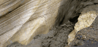
Mosaic Canyon is a showcase of geologic features as well as a beautiful example of one of Death Valley’s many canyons. Located 1/4 mile west of Stovepipe Wells Village, the 2 mile gravel access road climbs 1000 ft. to the parking area. From here an easy 1/4 mile walk leads into the canyon narrows, where the surrounding rock walls are composed of smooth, water-polished marble. If time permits, you can continue hiking for another 1-1/2 to 2 miles before the way is blocked by a dry waterfall.
The canyon formed because a system of cracks, known as faults, developed in the area millions of years ago. Running water has been channeled into these faults for centuries and has gradually carved out the canyon to its present size. Mosaic Canyon is the drainage for the northern flank of Tucki Mountain, and channels water from a 4.3 square-mile area. Periodic flash floods continue to bring down sand, gravel and rock from the surrounding hills. This debris is deposited just past the canyon mouth. Over time, this continued deposition has built up the large wedge-shaped alluvial fan that extends down toward Stovepipe Wells.
Mosaic Canyon was named for a rock formation known as the "Mosaic Breccia." Breccia is the Italian word meaning "fragments". This formation is composed of angular fragments of many different kinds of parent rock, and it can be seen on the floor of the canyon just south of the parking area. The most common rock formation in the canyon is the Noonday Dolomite. This limestone is rich in magnesium and formed 750 to 900 million years ago when the area was part of the Pacific Ocean. This sedimentary material was later buried to great depths by younger materials and was subjected to pressures and temperatures exceeding 1000 degrees Fahrenheit. As a result, much of the limestone was altered, or metamorphosed, into marble. Subsequent uplift and erosion have since re-exposed these metamorphic rocks.
Mosaic Canyon is considered a geologic "outdoor museum", and as part of the National Park System, all of its features are protected by law. Enjoy the area, but please leave it undisturbed for future visitors. NO ROCK COLLECTING!
모래이고있는 홍수의 수색 작업은 조각과는 모자이크 캐년의 좁혀 연마했습니다.
모자이크 캐년은 지질 기능의 쇼케이스뿐만 아니라 데스 밸리의 많은 계곡 중 하나의 아름다운 예입니다. 난로의 연통 웰스 빌리지 2마일 자갈 액세스 도로가 주차장에 1,000피트을 기어의 1 / 4마일 서쪽에 위치해 있습니다. 주변 바위 벽이 부드러운 물 광택 대리석으로 구성되어있는 협곡이 좁아에 여기에서 쉽게 4분의 1 마일 거리에 연결됩니다. 시간이 허락하면 방법이 마른 폭포에 의해 차단되기 전에, 다른 1-1/2 2 마일 하이킹을 계속할 수 있습니다.
오류로 알려진 균열의 시스템은 전에 년의 지역 수백만에서 개발 때문에 협곡은 형성 될 수있다. 물을 실행하면 수세기 동안 이러한 결함으로 뚫어되어 점차적으로 현재의 크기로 협곡을 조각했습니다. 모자이크 캐년은 4.3 평방 마일 지역에서 북부 Tucki 산의 측면을 공격하고, 채널 물을 배수입니다. 정기 홍수는 주변 언덕에서 모래, 자갈과 바위를 가지고하고 있습니다. 이 쓰레기는 단지 협곡 입 지난 입금됩니다. 시간이 지남에 따라이 계속 증착은 실크 해트 웰스 향해 아래로 확장 쐐기 모양의 대형 충적 팬을 구축하고 있습니다.
모자이크 캐년은로 알려진 바위 이름을 따서 붙였다 "모자이크 각력암." 각력암은 "조각"을 의미 이탈리아 단어입니다. 이 형성 부모 바위의 여러 가지 각도 조각으로 구성되어 있으며, 단 남쪽 주차장의 협곡의 바닥에 볼 수 있습니다. 그랜드 캐년에서 가장 일반적인 바위는 정오 백운석입니다. 이 석회암은 마그네슘이 풍부하고 지역이 태평양의 한 부분 일 때 750-900,000,000년 전에 형성되었다. 이 침전물의 자료는 나중에 젊은 물질에 의해 훌륭한 깊이에 묻힌 및 압력 1000 화씨를 초과하는 온도를 받게되었습니다. 그 결과, 많은 석회암은 대리석으로, 변경, 또는 metamorphosed되었습니다. 이러한 metamorphic 바위를 다시 노출 이후 후속 고양과 침식이 있습니다.
모자이크 캐년은 지질 "야외 박물관"으로 간주하고 있으며, 국립 공원 시스템의 일부로서, 그 모든 기능은 법에 의해 보호됩니다. 지역을 즐길 수 있지만, 미래의 방문자에 대한이 방해받지 남겨주세요. NO ROCK 수집은 안됩니다!
'세계여행 > 나홀로 배낭 여행_국외' 카테고리의 다른 글
| 0301-13, Death Valley #15_ Zabriskie View point (0) | 2013.03.08 |
|---|---|
| 0301-13, Death Valley #14_ Zabriskie View point (0) | 2013.03.08 |
| 0301-13, Death Valley #11_Badwater (0) | 2013.03.07 |
| 0301-13, Death Valley #10_Borax (0) | 2013.03.07 |
| 0301-13, Death Valley #9_ Golden Canyon (0) | 2013.03.06 |


